Neighbourhood Plans and Subdivision Projects
Neighbourhood planning is done through a district plan. This plan enables the coherent organisation of a sector mainly intended for housing. All new constructions must comply with the requirements of the district plan.
If you want to develop a new residential area and want to clearly define the objectives to be achieved; if you are looking for the best possible division of your plots or have questions about access to the plots; we can help you.
The municipal by-laws provide the framework, while the district plan sets out the practical aspects, including:
-
- The layout and orientation of the building
- Integration into the environment
- The facilities needed
-
- Outdoor areas
- The deadline for completion
- …
For all these issues, GEO4ME brings you its experience in defining what is achievable, setting a timeline and coordinating the survey process.

Zone plans
Like building regulations, a zoning plan is an instrument used in municipal land use planning. It brings the visions and principles of the master plan to life at a municipal level. It allocates a zone of land use for a town.
GEO4ME can assist you in the creation of zoning plans for your municipality:
-
- Production of the plan
- Zone definition and area calculation
- Collecting the data required to draw up an area plan (archaeological zones, danger zones, water areas, forest areas etc.).
-
- Revaluation of cadastral taxes (link to G1_6)
- Assistance in drafting building regulations

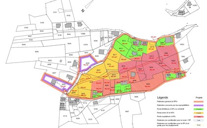
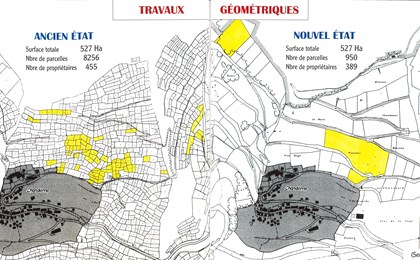
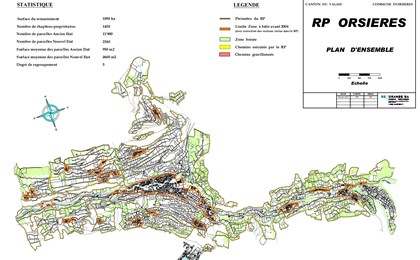
Urban plot reorganisation
Land parcel realignment (or reparcelling) consists of achieving a better distribution of the plots within a given perimeter, so as to optimise their size and density as well as the use of new facilities.

Do you have a project to redesign a plot of land? GEO4ME can offer you its expertise for all stages of the project.
Alignment plans
Alignment plans are part of the allocation plan category. They are a planning tool whose purpose is to reserve free space for the construction of public transport routes.
GEO4ME can support you in the different steps when drawing up alignment plans:
-
- Analysis of existing public roads
- Drawing up a design concepts
- Establishment of standard profiles
-
- Drawing up alignment plans and a report
- Approval procedure

References - Land use planning