Geodata Management
Geodata, data describing geographic information, is part of our daily lives. We use it to move around, to manage territories, to ensure the safety of goods and people, to trade, to study the past etc. Geodata is no longer reserved exclusively for experts and is now available to all.
GEO4ME helps you to prepare and adapt the data that you are going to bring to life and enhance in your projects.
There is no longer any technical limit in the creation of georeferenced data, but it is necessary to have the appropriate tools to do it.
We are here to guide and direct you towards the best way to create, enrich and use your data. Our equipment, with tailor-made tools, is at your disposal if you wish to go out into the field yourself and enter your data. Once the fieldwork is completed, we store your data, transform it in order to adapt it to your use and make it available to you in the form of your choice.

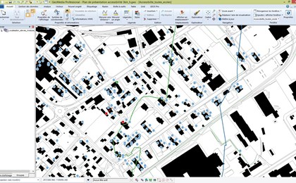
Spatial data plans and analyses
Locating elements in space is not only of visual interest, we can also study the links between objects of different natures but which have effects on each other. It is possible, for example, to project the flooding of a river onto adjacent land and thus define flood zones.
We provide you with our specialised data analysis tools and expertise in order to best use the data.

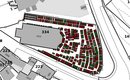
Thematic maps
In the field of communication visual examples are the most effective.
GEO4ME uses the information from your data to make a map that shows, for example, where rubbish is collected according to the type of waste collected in order to highlight areas that are not covered or, on the contrary, are over-covered.
There is also sometimes information in the geometry of the data such as plot surfaces, lengths of water pipes, length of paths... We can thus calculate distances between points of interest or estimate land value.

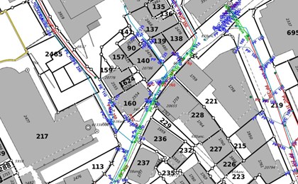
Geographical statistics
A map is a good way of analysing a situation as a whole from a spatial point of view, e.g. a representation of the values of energy consumption for heating in urban areas makes it possible to target the neighbourhoods to be renovated as a priority.
In the same way as for thematic maps, we analyse the information related to your data and pinpoint the information you are interested in. For example, we can calculate the value of a network such as a water network, count the number of gas leaks in a defined area or assess the energy needs per municipality.

Customised GIS
Are you a private individual (farmers, winegrowers), a private company, a local authority or a public service (fire brigade, police, emergency services, EM disasters, etc.) and you have information that you would like to centralise, analyse, enhance or disseminate?
GEO4ME's GIS solution is there for you.
Our solid experience in the field of GIS is there to offer you the following advantages:
-
- Centralised and continuously updated information
- Real-time access to data
- A possibility to update the data
- Unlimited number of computers (private or public)
-
- Personalised advice in the initial approach and in day-to-day management
- A link with your external data (CAPITASTRA, ValReg, owner register, professional data)
From the simple consultation of land registry data to the collection of information in the field, you are in control of your GIS and your data.

Customised module development
Do you have a project but lack the technical skills to implement it ?
We are at your service to study your needs and offer you tailored solutions.
GEO4ME brings together technical skills in a wide range of fields such as road construction, site management, water network management, creation of 3D models, printing of plans, expertise in official cadastral surveying, management of IT equipment, database management, photogrammetry, IT development etc... In order to meet your needs, we combine the necessary areas of expertise with respect to your area of interest.

Process Optimisation
Some repetitive manual tasks are a waste of time for your projects. We offer solutions and hardware such as data entry tools and tablets to speed up the data acquisition phases and also for the creation of reports.
For example, you can automate sending reports according to predefined criteria. We create a report template for you and the information is filled in automatically according to the instructions given by you or your customers.
We can also combine your analysis, calculation and reporting steps into a single process, saving you time and allowing you to focus directly on getting the most out of this information.

Accessibility analyses (schools, hydrant bollards, moloks, parking spaces...)
The first use that comes to mind when talking about geographical data is route calculation.
GEO4ME helps you to find the best routes for your school collections, your household waste management or your parking spaces. It is possible to combine information such as the places where pupils live in the city with the schools that they go to and the school transport routes to be set up.

Civil security
Civil security not only needs all the information available to be able to act quickly but also to protect civilians and responders in a crisis (finding the nearest hydrants, knowing the access points to a building, knowing how many people are potentially in a building, knowing how to evacuate people from an area in danger, whether there is a risk of photovoltaic panels exploding etc.).
We have the expertise in this field to provide the tools necessary not only for a quick and effective intervention but also to organise the data and make it available to the rescue services in the clearest possible way.

References - Geoinformatics